InSight mission
mission specific
Mission Summary
InSight is part of NASA’s Discovery Program. InSight is a mission dedicated to NASA’s efforts to understand the fundamental processes of terrestrial-planet formation and evolution by performing a comprehensive surface-based geophysical investigation of Mars. InSight will provide key information on the composition and structure of an Earth-like planet that has gone through most of the evolutionary stages of the Earth up to, but not including, plate tectonics. Thus, the traces of this history are still contained in the basic parameters of Mars: the size, state and composition of the core, the composition and layering of the mantle, the thickness and layering of the crust, and the thermal flux from the interior. These science objectives could be accomplished by landing nearly anywhere on the surface of Mars. The engineering rationale for landing in Elysium Planitia is described in Section 2.5.
InSight will launch on March 4, 2016 with a 23-day launch period duration, on an Atlas V-401 from the Vandenberg Air Force Base (VAFB) launch facility on a Type 1 trajectory to Mars. After a 7-month cruise, InSight will land on the surface of Mars on September 28, 2016. Following landing there is a p eriod of approximate 69 sols for the deployment and characterization of the instruments. After successful deployment of the instruments, InSight will perform science surface monitoring operations for one Mars year (two Earth years—September 2016 to September 2018).
InSight will address the mission science objectives by focusing on three scientific investigations: seismology, precision-tracking and heat-flow measurements. In order to obtain this information, InSight will use two scientific instruments: a seismometer and a self-penetrating mole trailing an instrumented tether for determining heat flux. In addition, InSight uses an X-band transponder (part of the Spacecraft Telecom Subsystem) to enable two-way precision Doppler tracking of the planet’s rotation. A suite of auxiliary sensors and payload elements, described below, support these measurements.
Mission Objectives
The overall goal of the InSight mission is to improve our understanding of terrestrial planet formation and evolution by understanding the origin and evolution of Mars. InSight investigates Mars’ interior structure, thermal and chemical evolution, and geologic processes. It also determines Mars’ present level of geologic activity and impact flux. InSight reveals the processes of formation and differentiation of the Martian core and crust, and illuminates the evolution of its interior by constraining the following parameters:
- Determine the depth of the crustal-mantle boundary to within ±10 km
- Detect any regional-scale crustal layering with velocity contrast >= 0.5 km/s over a depth interval >= 5 km
- Determine the seismic velocities in the upper 600 km of mantle to within ±0.25 km/s
- Determine whether the outer core is liquid or solid to a 90% confidence level
- Determine the core radius to within ±200 km
- Determine the core density to within ±450 kg/m3
- Determine the heat flux at the landing site to within ±5 mW/m2
- Determine the rate of seismic activity to within a factor of 2 for rates greater than 2x10¹⁸ Nm/yr
- Determine epicenter distance to ±25% and epicenter azimuth to ±20°
- Determine the rate of meteorite impacts to within a factor of 2
InSight Science Team
The science instruments, with an acronym or abbreviation and Principal Investigator (PI) are listed below:
|
Name
|
Institute
|
|---|---|
|
Bruce Banerdt |
Principle Investigator (PI), Jet Propulsion Laboratory (JPL) |
|
Suzanne Smrekar |
Deputy PI/Project Scientist, Jet Propulsion Laboratory (JPL) |
|
Robert Fogel |
Program Scientist, NASA Headquarters |
|
Philippe Lognonné |
SEIS PI, Institut de Physique du Globe de Paris (IPGP) |
|
Tilman Spohn |
HP3 PI, DLR Institute of Planetary Research |
|
William Folkner |
RISE PI, Jet Propulsion Laboratory (JPL) |
|
Sami Asmar |
Jet Propulsion Laboratory (JPL) |
|
Don Banfield |
Cornell University |
|
Ulrich Christensen |
Max Planck Institute for Solar System Research (MPS) |
|
Véronique Dehant |
Royal Observatory of Belgium (ROB) |
|
Raphael Garcia |
Institut Supérieur de l'Aéronautique et de l'Espace (ISAE) |
|
Domenico Giardini |
Swiss Federal Institute of Technology (ETHZ) |
|
Matt Golombek |
Jet Propulsion Laboratory (JPL) |
|
Matthias Grott |
DLR Institute of Planetary Research |
|
Troy Hudson |
Jet Propulsion Laboratory (JPL) |
|
Catherine Johnson |
University of British Columbia (UBC), Planetary Science Institute (PSI) |
|
Günter Kargl |
Austrian Academy of Sciences (ÖAW) |
|
Brigitte Knapmeyer-Endrun |
Max Planck Institute for Solar System Research (MPS) |
|
Naoki Kobayashi |
University Tokyo/Japanese Space Agency (JAXA) |
|
Justin Maki |
Jet Propulsion Laboratory (JPL) |
|
David Mimoun |
Institut Supérieur de l'Aéronautique et de l'Espace (ISAE) |
|
Antoine Mocquet |
Université de Nantes |
|
Paul Morgan |
Colorado School of Mines |
|
Mark Panning |
University Florida |
|
Tom Pike |
Imperial College, London (ICL) |
|
Jeroen Tromp |
Princeton University |
|
Renee Weber |
NASA-Marshall Space Flight Center (MSFC) |
|
Mark Wieczorek |
Institut de Physique du Globe de Paris (IPGP) |
Landing Site Selection
InSight will land in western Elysium Planitia on Hesperian plains just north of the dichotomy boundary. The 130 km by 27 km ellipse (E9) is located on smooth plains with Noachian highlands to the south and west, a ridge of Medussae Fossae Formation to the southeast and very young lavas from Athabasca Valles to the east. The E9 ellipse is located at 4.4°N, 135.8°E about 540 km north of the Curiosity landing site (see figure below).
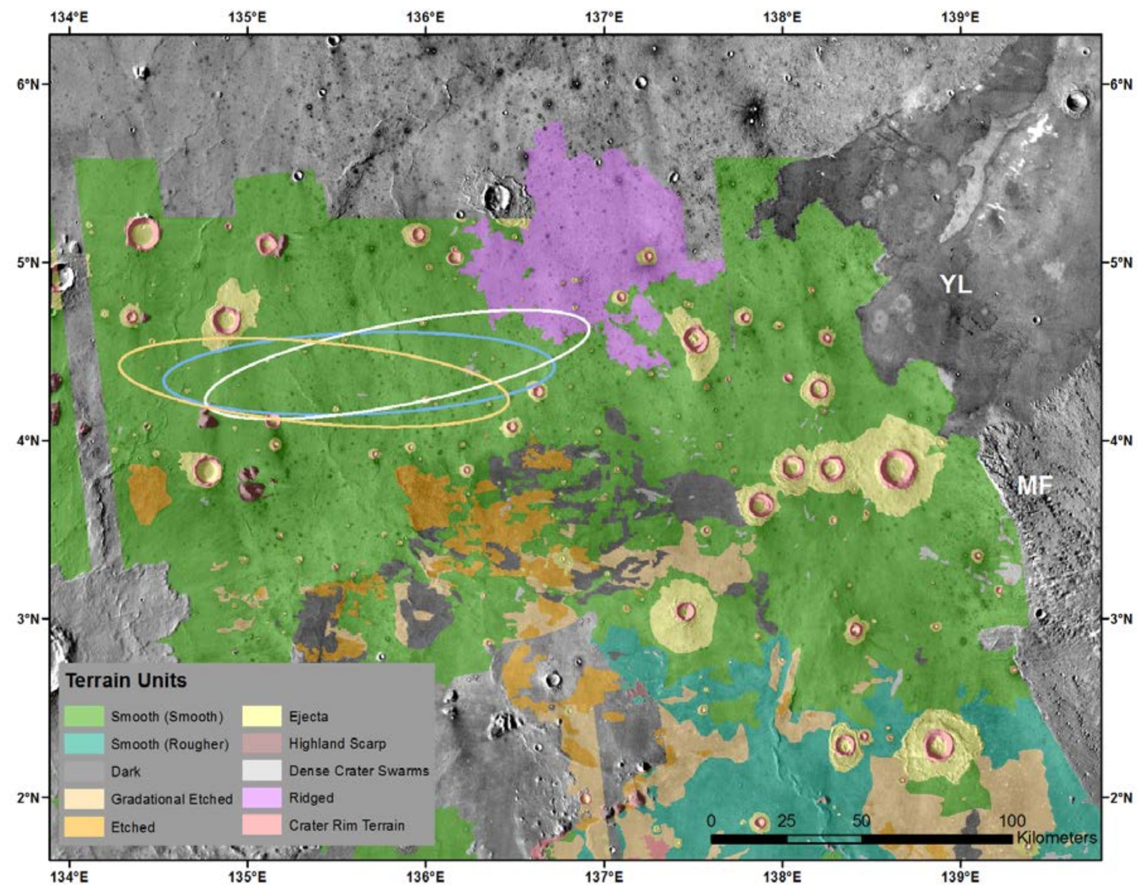
Map of the InSight landing ellipse E9, showing the ellipses (130 km by 27 km) for launch at the opening (white), middle (blue) and close (orange) of the launch opportunity. Terrain units as defined in Wigton et al. [2014], with the ellipse located dominantly on the smooth terrain (green), which is smooth, flat and has few rocks. The ellipse is about 600 km north of the dichotomy boundary and is likely underlain by Early Hesperian basalts superposed by a 5- 13 m surficial unit of impact-generated regolith. Noachian highlands are to the south and west (with remnant massifs rising through the plains), a ridge of Medussae Fossae Formation to the southeast (marked MF) and very young lavas from Athabasca Valles to the east (marked YL). Base map is THEMIS daytime thermal image mosaic, so cooler areas are darker and have higher thermal inertia due to more rocks or higher cohesion (note dark young lavas). Note dark, rocky ejecta craters on the plains are limited in size to less than roughly 2 km diameter and greater than around 50- 200 m diameter indicating a strong layer between 5-20 m and 200 m depth (and weaker sediments above and below) [Golombek et al., 2013a; Warner et al., 2014; Pivarunas et al., 2015].
The plains surface on which the InSight ellipse is located is mapped as an Early Hesperian transition unit (eHt) by Tanaka et al. (2014), which could be sedimentary or volcanic. A volcanic interpretation of the plains in the area of the InSight ellipses is supported by: 1) the presence of rocks in the ejecta of fresh craters ~0.2-20 km diameter arguing for a strong competent layer ~20-200 m deep [e.g., Golombek et al., 2013a; Catling et al., 2011, 2012], 2) exposures of strong, jointed bedrock overlain by ~10 m of fine grained regolith in nearby Hephaestus Fossae in southern Utopia Planitia at 21.9°N, 122.0°E [Golombek et al., 2013a], and 3) the presence of wrinkle ridges, which have been interpreted to be fault-propagation folds, in which slip on thrust faults at depth is accommodated by asymmetric folding in strong, but weakly bonded layered material (aka basalt flows) near the surface [e.g., Mueller and Golombek, 2004].
The primary landing safety engineering requirements for InSight landing site selection are [Golombek et al., 2013b]:
- MOLA elevation below -2.5 km for sufficient atmosphere to slow the spacecraft during entry, descent, and landing
- Latitude 3°N to 5°N for solar-power margins
- Ellipse size 130 km × 27 km for ~99% landing accuracy
- Smooth, flat, radar-reflective surface
- Thermal inertia >100–140 J m-2 K-1 s-1/2 for a load-bearing surface without substantial fine-graineddust
- Rock abundance <= 10% for a ~<1% probability of impacting a rock that could damage the base of the lander or impede opening the solar panels
- Regional (84 m length scale) and local terrain slopes (2-5 m length scale) <15° for radar tracking and touchdown stability
The instrument deployment requirements include: Rock abundance <10% and slopes <15° (same as for landing safely) and a broken up regolith >5 m thick to allow full penetration of the HP3 mole. There are no science requirements on the landing site. All of these requirements are met by ellipse E9.
Landing site selection for InSight has taken about three years. The original Discovery Mission proposal included a reference ellipse in Elysium Planitia that appeared to meet the engineering constraints. At the end of phase A (5/12), the project had identified 16 ellipses and began requesting HiRISE and CTX images [Golombek et al., 2013b]. Within about 1 year CTX had acquired about 90% coverage of these ellipses, that together with HiRISE images, allowed the mapping of terrains. These ellipses included both a smooth terrain that appeared exceptionally benign (very smooth with few rocks) and etched terrain (rougher with higher rock abundance) as well as transitional units [Golombek et al., 2013a; Wigton et al., 2014]. Additional HiRISE images revealed a substantial number of secondary craters that extend in rays ~1400 km to the south of Corinto crater, a fresh crater about 1000 km to the north of prospective landing sites [Golombek et al., 2014a; Bloom et al., 2014]. The project downselected to 4 ellipses in July 2013 that are located dominantly on the smooth terrain [Golombek et al., 2014b].
The Council of Terrains and Council of Atmospheres were established in February 2014 to create data products to assist in surface characterization (e.g., digital elevation, slope and rock maps) and reference atmospheres for entry and descent simulations. During landing site evaluation, HiRISE, CTX and HRSC images were processed into digital elevation maps, MOLA data were examined to identify steep slopes at 100 m length scale, HiRISE data were used to create photoclinometry slope maps and rock maps, radar and SHARAD data were analyzed to understand reflectivity and subsurface layering, thermal data were examined to understand the physical properties of surface materials, terrain units were mapped in CTX and HiRISE images, and rocky ejecta craters were mapped and fracture and fragmentation theory applied to the Elysium plains to understand regolith thickness. The second project down selection occurred in January 2015, which provisionally selected ellipse E9. Project certification of the ellipse will occur in the fall of 2015.
Thermophysical properties of the landing ellipse in remote sensing data and comparison to existing landing sites [e.g., Golombek et al., 2008] suggests the InSight surfaces are composed of cohesionless sand or low cohesion soils [Golombek et al., 2013a]. The albedo and dust cover index are similar to dusty and low-rock abundance portions of the Gusev cratered plains [Golombek et al., 2006] and dust devil tracks are common in HiRISE images. Mapping of rocky ejecta craters in extensive HiRISE images of the ellipses indicates a broken up regolith produced by cratering since the Hesperian that is 5-13 m thick [Warner et al., 2014; Pivarunas et al., 2015], likely similar to the impact generated regolith at the Gusev cratered plains [e.g., Golombek et al., 2006] and thus conducive for full penetration of the HP3 mole.
Mission Planning
The following sections describe the phases of the InSight mission, from launch through the end of surface operations. The timeline and primary activities are summarized for each phase.
Launch, Cruise, Approach, and EDL Phases
The current baseline launch window for InSight extends from March 4 to March 26, 2016. For a launch on any date during this window, Entry, Descent, and Landing (EDL) will occur September 28, 2016. Cruise operations concentrate on monitoring the health and performance of the flight systems and navigating the spacecraft to Mars. Spacecraft engineering subsystems checkouts, calibration activities, and instrument payload aliveness checkouts are performed early during cruise operations. Other than the checkouts/calibrations 24 days post-launch, all payloads are off during this phase.
During the cruise to Mars, the spacecraft will perform Trajectory Correction Maneuvers (TCMs). The last 60 days before landing compromise the approach phase, involving additional trajectory correction maneuvers. Entry, descent, and landing activities occur within ~10 minutes prior to landing on Mars. InSight uses a heatshield, parachute, and thruster-controlled lander descent stage to reach the surface. Immediately after touchdown, the lander configures itself for landed operations including deploying both solar arrays and taking an image using the ICC.
Deployment
Instrument deployment begins when the solar arrays are deployed and the lander is in a safe and communicative state. Instrument deployment operations take approximately 42 to 60 sols and cover assessment of the landed workspace, determination of instrument deployment sites, deployment of the instruments (HP3 and SEIS, including the WTS), and the release of the HP3 mole. The figure below provides an overview of all the activities required for successful deployment of the instruments. During this phase, the lander, its surrounding environment, and the workspace are characterized, the payload elements are checked out, weekly RISE measurements are acquired, and the critical data collected on Sol 0—the landing sol—are relayed to Earth. After the Science Team has selected suitable deployment sites within the workspace, the IDA places the SEIS (and covering WTS) and HP3 instruments on the surface of Mars. At that point instrument calibration and science data collection commences and the HP3 mole is released for penetration activity.
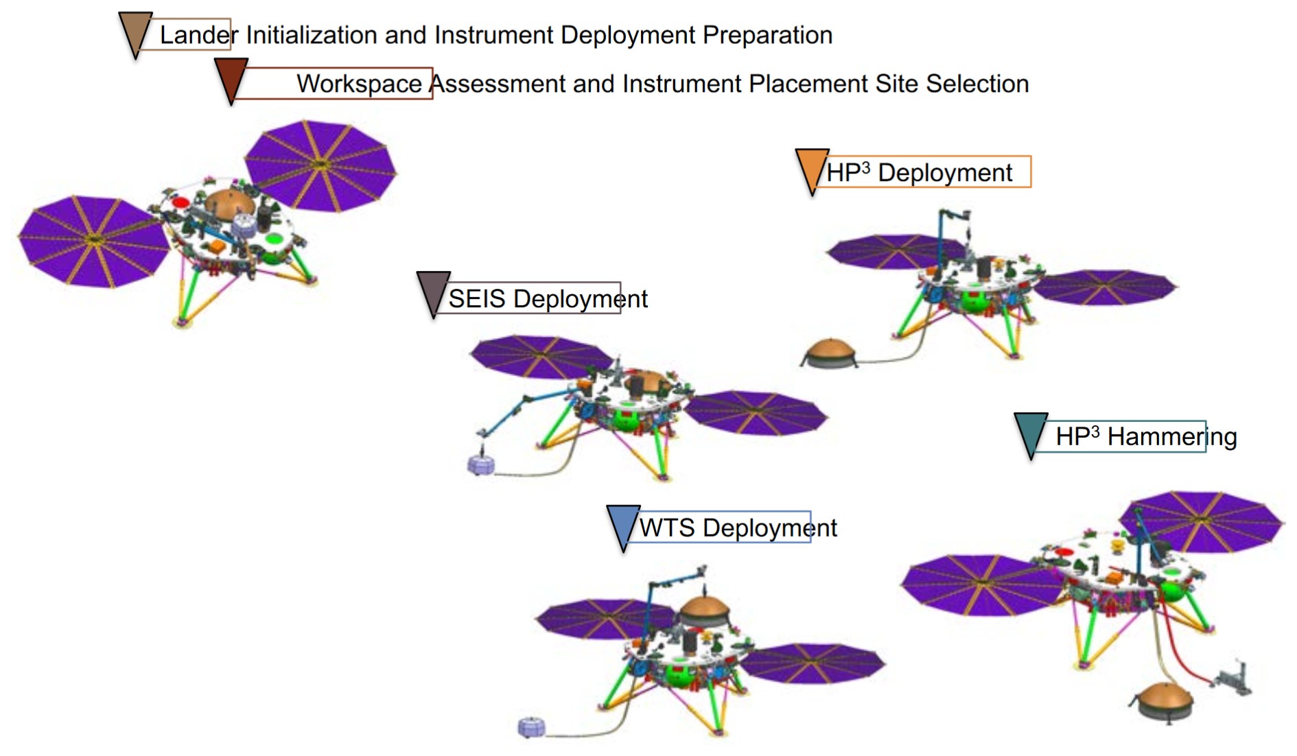
Overview of required activities and timeline for Instrument Deployment
The selection of the instrument deployment sites will be governed by the Instrument Site Selection Working Group (ISSWG) and consist of four main phases:
- Initial qualitative assessment of the workspace
- Systematic mapping of the workspace
- Quantitative assessment of four prospective sites
- Certification of two prospective sites
Analysis data products utilized in this assessment include: 4 mm Digital Elevation Maps (DEMs), maps of the slope, roughness, surface normal, and tilt, terrain and soil maps with soil physical properties assessment, rock map with size-frequency distribution and shadow map, SEIS noise map, HP3 thermal map, instrument tether routing, and mole penetrability assessment.
Due to the nature of the deployment timeframe, a rapid analysis of lander and payload telemetry is performed to assess the health and safety of the engineering subsystems and the status of instrument deployment activities. During this phase, InSight personnel will be co-located at JPL and work on a modified Earth-time schedule in which the start of the shift on Earth will track Mars time, sliding forward from 6 AM until it reaches 1 PM. After this point, the downlink from Mars arrives too late in the day on Earth to allow commands to be generated before a reasonable end of shift (a 10-hour shift is planned for deployment). Operations will be nominally planned daily with two floating days off per week. Due to the intensive and highly scripted nature of the deployment phase, limited, if any, time is expected to be available for ancillary science to be added during this phase. Operational support for the IDA is only planned for the deployment timeframe. Any IDA operation after the deployment phase is on a best efforts basis.
Science Monitoring
The science monitoring operations begin after the instruments have been placed on the surface. During this phase, SEIS monitoring starts and the HP3 mole penetrates to its final depth. During the science monitoring operations, SEIS and HP3 are in nominal data collection mode and gather science data autonomously and continuously and store this data in the instruments’ nonvolatile memory. The lander nominally provides continuous power to SEIS and HP3 throughout this phase, collects data from the instruments during every full wake up, and relays the data to Earth, usually twice per sol. The lander powers on the RISE X-band communications system for one-hour an average of four times per week during which Doppler-tone monitoring sessions with the DSN are performed. The radiometer (part of HP3) is commanded to take four 1-hour measurements during each sol for five minutes duration each, and every Ls ~ 15°, an hourly radiometer measurement campaign is undertaken lasting one entire sol with one measurement per hour for five minutes duration in each instance. The active TWINS’ boom is swapped several times per sol to account for changing wind direction.
Since the lander is solar powered, the life of the lander is driven by Mars’ diurnal cycle. Lander communications are determined by when orbiter overflights allow for UHF relay, typically twice per day at 3 AM and 6 PM LMST. The lander spends the majority of the science monitoring operations asleep. On a typical sol, the lander wakes up every three hours to check the battery state of charge, to run FSW diagnostics and fault-protection checks, and to collect housekeeping data. During two of the daily wake cycles the lander stays awake for an additional time to process science data and relay the data to an orbiter asset. Although science data are relayed back to Earth twice per sol, commands are relayed to the lander only once per week. A representative sol from the science monitoring operations is depicted in the figure below.
Science monitoring operations are simple and routine. No ground-in-the-loop is required under nominal conditions. The flight team works on Earth time, and only during the nominal 8-hr prime shift. All operations teams reside at their respective institutions, and the SEIS and HP3 IOTs work standard shifts for the time zone of their institutions. Operations are performed using a strategic process/timeline with sequences for the lander uplinked a week at a time. The rapid turnaround process supported during instrument deployment will no longer be used, although anomaly resolution will continue to be supported in that manner. Seismic and APSS event data selection by the instrument and science teams will be performed. Operations processes and interfaces will accommodate time differences for nominal operations between the different institutions supporting Science Monitoring operations.
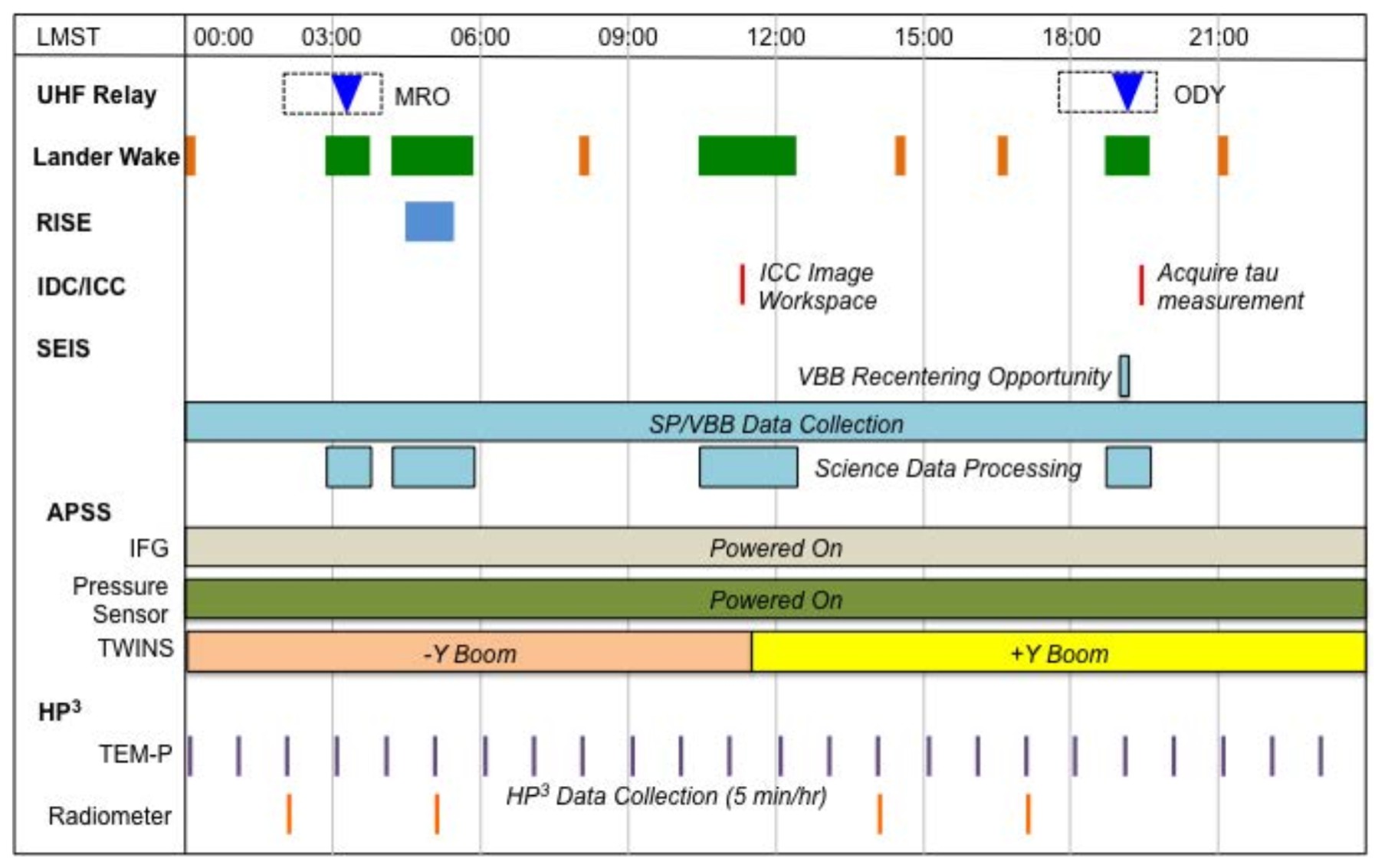
Sample lander activities during a nominal science monitoring sol.